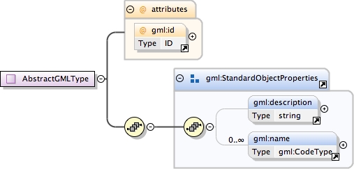
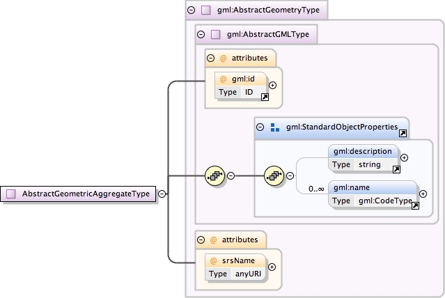
Database handle for the object.  It is of XML type ID,
            so is constrained to be unique in the XML document within
            which it occurs.  An external identifier for the object
            in the form of a URI may be constructed using standard XML
            and XPointer methods.  This is done by concatenating the
            URI for the document, a fragment separator, and the value
            of the id attribute.
In general this reference points to a CRS instance of
                     gml:CoordinateReferenceSystemType (see
                     coordinateReferenceSystems.xsd). For well known
                     references it is not required that the CRS description
                     exists at the location the URI points to. If no srsName
                     attribute is given, the CRS must be specified as part of
                     the larger context this geometry element is part of, e.g.
                     a geometric element like point, curve, etc. It is expected
                     that this attribute will be specified at the direct
                     position level only in rare cases.
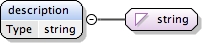
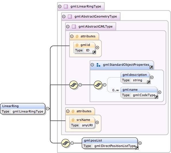
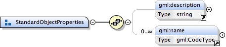
<element name="description" type="string"><annotation><documentation>Contains a simple text description of the object.</documentation><documentation>Restricted to only allow a text string, as done in GML 3.2.</documentation></annotation></element>
Schema location
http://www.tridas.org/1.2/gmlsf.xsd
Element gml:name
Namespace
http://www.opengis.net/gml
Annotations
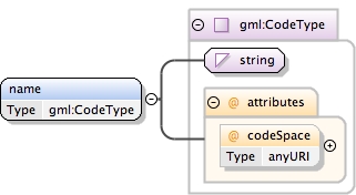
Label for the object, normally a descriptive name. An
            object may have several names, typically assigned by
            different authorities.  The authority for a name is
            indicated by the value of its (optional) codeSpace
            attribute.  The name may or may not be unique, as
            determined by the rules of the organization responsible
            for the codeSpace.
<element name="name" type="gml:CodeType"><annotation><documentation>Label for the object, normally a descriptive name. An object may have several names, typically assigned by different authorities. The authority for a name is indicated by the value of its (optional) codeSpace attribute. The name may or may not be unique, as determined by the rules of the organization responsible for the codeSpace.</documentation></annotation></element>
Database handle for the object.  It is of XML type ID,
            so is constrained to be unique in the XML document within
            which it occurs.  An external identifier for the object
            in the form of a URI may be constructed using standard XML
            and XPointer methods.  This is done by concatenating the
            URI for the document, a fragment separator, and the value
            of the id attribute.
In general this reference points to a CRS instance of
                     gml:CoordinateReferenceSystemType (see
                     coordinateReferenceSystems.xsd). For well known
                     references it is not required that the CRS description
                     exists at the location the URI points to. If no srsName
                     attribute is given, the CRS must be specified as part of
                     the larger context this geometry element is part of, e.g.
                     a geometric element like point, curve, etc. It is expected
                     that this attribute will be specified at the direct
                     position level only in rare cases.
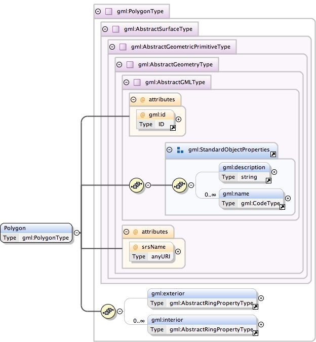
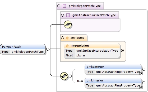
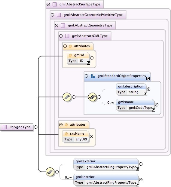
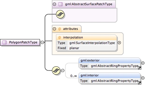
A boundary of a surface consists of a number of rings.
            In the normal 2D case, one of these rings is distinguished
            as being the exterior boundary. In a general manifold this
            is not always possible, in which case all boundaries shall
            be listed as interior boundaries, and the exterior will be
            empty.
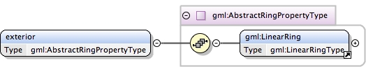
<element name="exterior" type="gml:AbstractRingPropertyType"><annotation><documentation>A boundary of a surface consists of a number of rings. In the normal 2D case, one of these rings is distinguished as being the exterior boundary. In a general manifold this is not always possible, in which case all boundaries shall be listed as interior boundaries, and the exterior will be empty.</documentation></annotation></element>
Database handle for the object.  It is of XML type ID,
            so is constrained to be unique in the XML document within
            which it occurs.  An external identifier for the object
            in the form of a URI may be constructed using standard XML
            and XPointer methods.  This is done by concatenating the
            URI for the document, a fragment separator, and the value
            of the id attribute.
In general this reference points to a CRS instance of
                     gml:CoordinateReferenceSystemType (see
                     coordinateReferenceSystems.xsd). For well known
                     references it is not required that the CRS description
                     exists at the location the URI points to. If no srsName
                     attribute is given, the CRS must be specified as part of
                     the larger context this geometry element is part of, e.g.
                     a geometric element like point, curve, etc. It is expected
                     that this attribute will be specified at the direct
                     position level only in rare cases.
<element name="interior" type="gml:AbstractRingPropertyType"><annotation><documentation>A boundary of a surface consists of a number of rings. The "interior" rings seperate the surface / surface patch from the area enclosed by the rings.</documentation></annotation></element>
Schema location
http://www.tridas.org/1.2/gmlsf.xsd
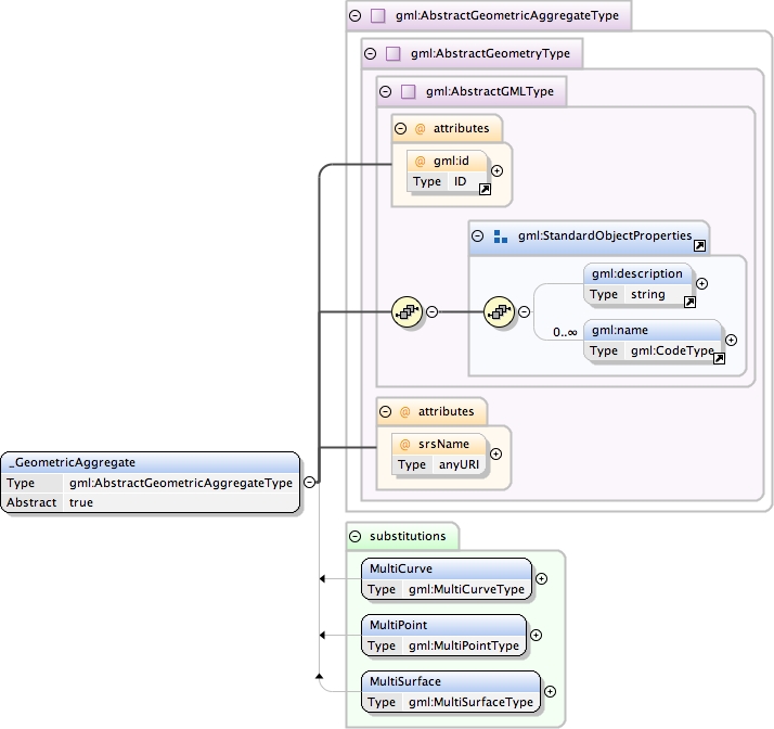
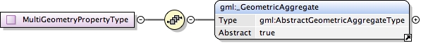
Element gml:_GeometricAggregate
Namespace
http://www.opengis.net/gml
Annotations
The "_GeometricAggregate" element is the abstract head of
            the substitution group for all geometric aggregates.
Database handle for the object.  It is of XML type ID,
            so is constrained to be unique in the XML document within
            which it occurs.  An external identifier for the object
            in the form of a URI may be constructed using standard XML
            and XPointer methods.  This is done by concatenating the
            URI for the document, a fragment separator, and the value
            of the id attribute.
In general this reference points to a CRS instance of
                     gml:CoordinateReferenceSystemType (see
                     coordinateReferenceSystems.xsd). For well known
                     references it is not required that the CRS description
                     exists at the location the URI points to. If no srsName
                     attribute is given, the CRS must be specified as part of
                     the larger context this geometry element is part of, e.g.
                     a geometric element like point, curve, etc. It is expected
                     that this attribute will be specified at the direct
                     position level only in rare cases.
Source
<element name="_GeometricAggregate" type="gml:AbstractGeometricAggregateType" substitutionGroup="gml:_Geometry" abstract="true"><annotation><documentation>The "_GeometricAggregate" element is the abstract head of the substitution group for all geometric aggregates.</documentation></annotation></element>
Database handle for the object.  It is of XML type ID,
            so is constrained to be unique in the XML document within
            which it occurs.  An external identifier for the object
            in the form of a URI may be constructed using standard XML
            and XPointer methods.  This is done by concatenating the
            URI for the document, a fragment separator, and the value
            of the id attribute.
In general this reference points to a CRS instance of
                     gml:CoordinateReferenceSystemType (see
                     coordinateReferenceSystems.xsd). For well known
                     references it is not required that the CRS description
                     exists at the location the URI points to. If no srsName
                     attribute is given, the CRS must be specified as part of
                     the larger context this geometry element is part of, e.g.
                     a geometric element like point, curve, etc. It is expected
                     that this attribute will be specified at the direct
                     position level only in rare cases.
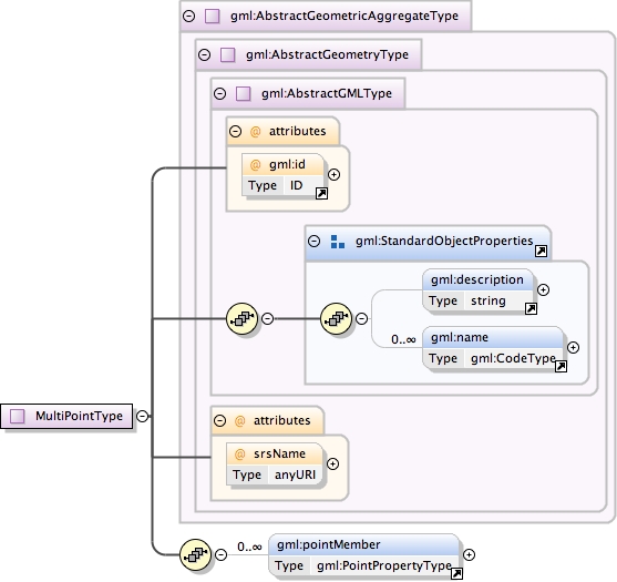
<element name="pointMember" type="gml:PointPropertyType"><annotation><documentation>This property element contains the Point element.</documentation></annotation></element>
Database handle for the object.  It is of XML type ID,
            so is constrained to be unique in the XML document within
            which it occurs.  An external identifier for the object
            in the form of a URI may be constructed using standard XML
            and XPointer methods.  This is done by concatenating the
            URI for the document, a fragment separator, and the value
            of the id attribute.
In general this reference points to a CRS instance of
                     gml:CoordinateReferenceSystemType (see
                     coordinateReferenceSystems.xsd). For well known
                     references it is not required that the CRS description
                     exists at the location the URI points to. If no srsName
                     attribute is given, the CRS must be specified as part of
                     the larger context this geometry element is part of, e.g.
                     a geometric element like point, curve, etc. It is expected
                     that this attribute will be specified at the direct
                     position level only in rare cases.
<element name="curveMember" type="gml:CurvePropertyType"><annotation><documentation>This property element contains the curve element. A curve element is any element which is substitutable for "_Curve".</documentation></annotation></element>
Schema location
http://www.tridas.org/1.2/gmlsf.xsd
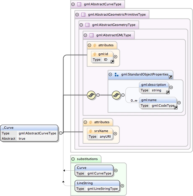
Element gml:_Curve
Namespace
http://www.opengis.net/gml
Annotations
The "_Curve" element is the abstract head of the
            substituition group for all (continuous) curve elements.
Database handle for the object.  It is of XML type ID,
            so is constrained to be unique in the XML document within
            which it occurs.  An external identifier for the object
            in the form of a URI may be constructed using standard XML
            and XPointer methods.  This is done by concatenating the
            URI for the document, a fragment separator, and the value
            of the id attribute.
In general this reference points to a CRS instance of
                     gml:CoordinateReferenceSystemType (see
                     coordinateReferenceSystems.xsd). For well known
                     references it is not required that the CRS description
                     exists at the location the URI points to. If no srsName
                     attribute is given, the CRS must be specified as part of
                     the larger context this geometry element is part of, e.g.
                     a geometric element like point, curve, etc. It is expected
                     that this attribute will be specified at the direct
                     position level only in rare cases.
Source
<element name="_Curve" type="gml:AbstractCurveType" substitutionGroup="gml:_GeometricPrimitive" abstract="true"><annotation><documentation>The "_Curve" element is the abstract head of the substituition group for all (continuous) curve elements.</documentation></annotation></element>
Database handle for the object.  It is of XML type ID,
            so is constrained to be unique in the XML document within
            which it occurs.  An external identifier for the object
            in the form of a URI may be constructed using standard XML
            and XPointer methods.  This is done by concatenating the
            URI for the document, a fragment separator, and the value
            of the id attribute.
In general this reference points to a CRS instance of
                     gml:CoordinateReferenceSystemType (see
                     coordinateReferenceSystems.xsd). For well known
                     references it is not required that the CRS description
                     exists at the location the URI points to. If no srsName
                     attribute is given, the CRS must be specified as part of
                     the larger context this geometry element is part of, e.g.
                     a geometric element like point, curve, etc. It is expected
                     that this attribute will be specified at the direct
                     position level only in rare cases.
<element name="surfaceMember" type="gml:SurfacePropertyType"><annotation><documentation>This property element contains the surface element. A surface element is any element which is substitutable for "_Surface".</documentation></annotation></element>
Schema location
http://www.tridas.org/1.2/gmlsf.xsd
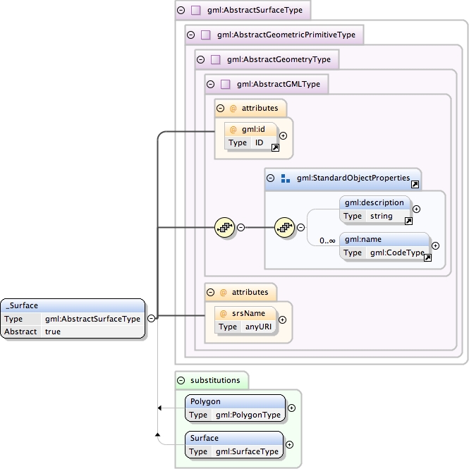
Element gml:_Surface
Namespace
http://www.opengis.net/gml
Annotations
The "_Surface" element is the abstract head of the
            substituition group for all (continuous) surface elements.
Database handle for the object.  It is of XML type ID,
            so is constrained to be unique in the XML document within
            which it occurs.  An external identifier for the object
            in the form of a URI may be constructed using standard XML
            and XPointer methods.  This is done by concatenating the
            URI for the document, a fragment separator, and the value
            of the id attribute.
In general this reference points to a CRS instance of
                     gml:CoordinateReferenceSystemType (see
                     coordinateReferenceSystems.xsd). For well known
                     references it is not required that the CRS description
                     exists at the location the URI points to. If no srsName
                     attribute is given, the CRS must be specified as part of
                     the larger context this geometry element is part of, e.g.
                     a geometric element like point, curve, etc. It is expected
                     that this attribute will be specified at the direct
                     position level only in rare cases.
Source
<element name="_Surface" type="gml:AbstractSurfaceType" substitutionGroup="gml:_GeometricPrimitive" abstract="true"><annotation><documentation>The "_Surface" element is the abstract head of the substituition group for all (continuous) surface elements.</documentation></annotation></element>
Database handle for the object.  It is of XML type ID,
            so is constrained to be unique in the XML document within
            which it occurs.  An external identifier for the object
            in the form of a URI may be constructed using standard XML
            and XPointer methods.  This is done by concatenating the
            URI for the document, a fragment separator, and the value
            of the id attribute.
In general this reference points to a CRS instance of
                     gml:CoordinateReferenceSystemType (see
                     coordinateReferenceSystems.xsd). For well known
                     references it is not required that the CRS description
                     exists at the location the URI points to. If no srsName
                     attribute is given, the CRS must be specified as part of
                     the larger context this geometry element is part of, e.g.
                     a geometric element like point, curve, etc. It is expected
                     that this attribute will be specified at the direct
                     position level only in rare cases.
<element name="segments" type="gml:CurveSegmentArrayPropertyType"><annotation><documentation>This property element contains a list of curve segments. The order of the elements is significant and shall be preserved when processing the array.</documentation></annotation></element>
Schema location
http://www.tridas.org/1.2/gmlsf.xsd
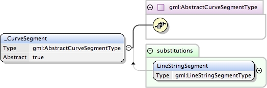
Element gml:_CurveSegment
Namespace
http://www.opengis.net/gml
Annotations
The "_CurveSegment" element is the abstract head of the
            substituition group for all curve segment elements,
            i.e. continuous segments of the same interpolation
            mechanism.
<element name="_CurveSegment" type="gml:AbstractCurveSegmentType" abstract="true"><annotation><documentation>The "_CurveSegment" element is the abstract head of the substituition group for all curve segment elements, i.e. continuous segments of the same interpolation mechanism.</documentation></annotation></element>
The attribute "interpolation" specifies
                     the curve interpolation mechanism used
                     for this segment. This mechanism uses
                     the control points and control parameters
                     to determine the position of this curve
                     segment. For a LineStringSegment the
                     interpolation is fixed as "linear".
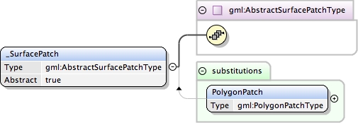
The "_SurfacePatch" element is the abstract head of the
            substituition group for all surface pach elements describing
            a continuous portion of a surface.
<element name="_SurfacePatch" type="gml:AbstractSurfacePatchType" abstract="true"><annotation><documentation>The "_SurfacePatch" element is the abstract head of the substituition group for all surface pach elements describing a continuous portion of a surface.</documentation></annotation></element>
Schema location
http://www.tridas.org/1.2/gmlsf.xsd
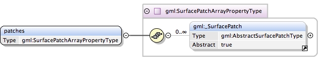
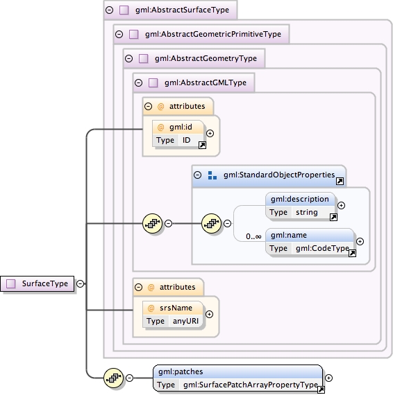
Element gml:patches
Namespace
http://www.opengis.net/gml
Annotations
This property element contains a list of surface patches.
             The order of the elements is significant and shall be
             preserved when processing the array.
<element name="patches" type="gml:SurfacePatchArrayPropertyType"><annotation><documentation>This property element contains a list of surface patches. The order of the elements is significant and shall be preserved when processing the array.</documentation></annotation></element>
The attribute "interpolation" specifies the
                     interpolation mechanism used for this surface
                     patch. Currently only planar surface patches
                     are defined in GML 3, the attribute is fixed
                     to "planar", i.e. the interpolation method
                     shall return points on a single plane. The
                     boundary of the patch shall be contained within
                     that plane.
Database handle for the object.  It is of XML type ID,
            so is constrained to be unique in the XML document within
            which it occurs.  An external identifier for the object
            in the form of a URI may be constructed using standard XML
            and XPointer methods.  This is done by concatenating the
            URI for the document, a fragment separator, and the value
            of the id attribute.
In general this reference points to a CRS instance of
                     gml:CoordinateReferenceSystemType (see
                     coordinateReferenceSystems.xsd). For well known
                     references it is not required that the CRS description
                     exists at the location the URI points to. If no srsName
                     attribute is given, the CRS must be specified as part of
                     the larger context this geometry element is part of, e.g.
                     a geometric element like point, curve, etc. It is expected
                     that this attribute will be specified at the direct
                     position level only in rare cases.
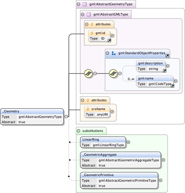
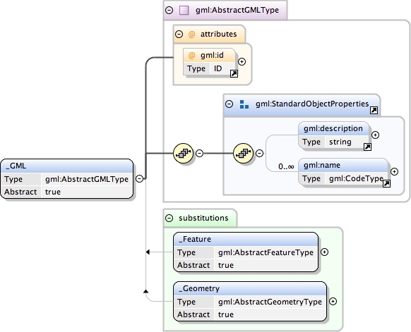
The "_Geometry" element is the abstract head of the
            substituition group for all geometry elements of GML 3.
            This includes pre-defined and user-defined geometry elements.
            Any geometry element must be a direct or indirect
            extension/restriction  of AbstractGeometryType
            and must be directly or indirectly in the substitution
            group of "_Geometry".
Database handle for the object.  It is of XML type ID,
            so is constrained to be unique in the XML document within
            which it occurs.  An external identifier for the object
            in the form of a URI may be constructed using standard XML
            and XPointer methods.  This is done by concatenating the
            URI for the document, a fragment separator, and the value
            of the id attribute.
In general this reference points to a CRS instance of
                     gml:CoordinateReferenceSystemType (see
                     coordinateReferenceSystems.xsd). For well known
                     references it is not required that the CRS description
                     exists at the location the URI points to. If no srsName
                     attribute is given, the CRS must be specified as part of
                     the larger context this geometry element is part of, e.g.
                     a geometric element like point, curve, etc. It is expected
                     that this attribute will be specified at the direct
                     position level only in rare cases.
Source
<element name="_Geometry" type="gml:AbstractGeometryType" substitutionGroup="gml:_GML" abstract="true"><annotation><documentation>The "_Geometry" element is the abstract head of the substituition group for all geometry elements of GML 3. This includes pre-defined and user-defined geometry elements. Any geometry element must be a direct or indirect extension/restriction of AbstractGeometryType and must be directly or indirectly in the substitution group of "_Geometry".</documentation></annotation></element>
Schema location
http://www.tridas.org/1.2/gmlsf.xsd
Element gml:_GeometricPrimitive
Namespace
http://www.opengis.net/gml
Annotations
The "_GeometricPrimitive" element is the abstract head of
            the substituition group for all (pre- and user-defined)
            geometric primitives.
Database handle for the object.  It is of XML type ID,
            so is constrained to be unique in the XML document within
            which it occurs.  An external identifier for the object
            in the form of a URI may be constructed using standard XML
            and XPointer methods.  This is done by concatenating the
            URI for the document, a fragment separator, and the value
            of the id attribute.
In general this reference points to a CRS instance of
                     gml:CoordinateReferenceSystemType (see
                     coordinateReferenceSystems.xsd). For well known
                     references it is not required that the CRS description
                     exists at the location the URI points to. If no srsName
                     attribute is given, the CRS must be specified as part of
                     the larger context this geometry element is part of, e.g.
                     a geometric element like point, curve, etc. It is expected
                     that this attribute will be specified at the direct
                     position level only in rare cases.
Source
<element name="_GeometricPrimitive" type="gml:AbstractGeometricPrimitiveType" abstract="true" substitutionGroup="gml:_Geometry"><annotation><documentation>The "_GeometricPrimitive" element is the abstract head of the substituition group for all (pre- and user-defined) geometric primitives.</documentation></annotation></element>
Database handle for the object.  It is of XML type ID,
            so is constrained to be unique in the XML document within
            which it occurs.  An external identifier for the object
            in the form of a URI may be constructed using standard XML
            and XPointer methods.  This is done by concatenating the
            URI for the document, a fragment separator, and the value
            of the id attribute.
In general this reference points to a CRS instance of
                     gml:CoordinateReferenceSystemType (see
                     coordinateReferenceSystems.xsd). For well known
                     references it is not required that the CRS description
                     exists at the location the URI points to. If no srsName
                     attribute is given, the CRS must be specified as part of
                     the larger context this geometry element is part of, e.g.
                     a geometric element like point, curve, etc. It is expected
                     that this attribute will be specified at the direct
                     position level only in rare cases.
In general this reference points to a CRS instance of
               gml:CoordinateReferenceSystemType (see
               coordinateReferenceSystems.xsd). For well known
               references it is not required that the CRS description
               exists at the location the URI points to.
Database handle for the object.  It is of XML type ID,
            so is constrained to be unique in the XML document within
            which it occurs.  An external identifier for the object
            in the form of a URI may be constructed using standard XML
            and XPointer methods.  This is done by concatenating the
            URI for the document, a fragment separator, and the value
            of the id attribute.
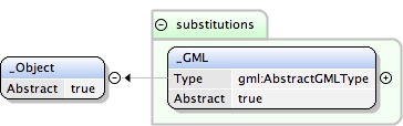
This abstract element is the head of a substitutionGroup
            hierararchy which may contain either simpleContent or
            complexContent elements.  It is used to assert the model
            position of "class" elements declared in other GML schemas.
Diagram
Properties
abstract:
true
Source
<element name="_Object" abstract="true"><annotation><documentation>This abstract element is the head of a substitutionGroup hierararchy which may contain either simpleContent or complexContent elements. It is used to assert the model position of "class" elements declared in other GML schemas.</documentation></annotation></element>
Schema location
http://www.tridas.org/1.2/gmlsf.xsd
Element gml:_GML
Namespace
http://www.opengis.net/gml
Annotations
Global element which acts as the head of a substitution group
            that may include any element which is a GML feature, object,
            geometry or complex value
Database handle for the object.  It is of XML type ID,
            so is constrained to be unique in the XML document within
            which it occurs.  An external identifier for the object
            in the form of a URI may be constructed using standard XML
            and XPointer methods.  This is done by concatenating the
            URI for the document, a fragment separator, and the value
            of the id attribute.
Source
<element name="_GML" type="gml:AbstractGMLType" abstract="true" substitutionGroup="gml:_Object"><annotation><documentation>Global element which acts as the head of a substitution group that may include any element which is a GML feature, object, geometry or complex value</documentation></annotation></element>
Database handle for the object.  It is of XML type ID,
            so is constrained to be unique in the XML document within
            which it occurs.  An external identifier for the object
            in the form of a URI may be constructed using standard XML
            and XPointer methods.  This is done by concatenating the
            URI for the document, a fragment separator, and the value
            of the id attribute.
In general this reference points to a CRS instance of
                     gml:CoordinateReferenceSystemType (see
                     coordinateReferenceSystems.xsd). For well known
                     references it is not required that the CRS description
                     exists at the location the URI points to. If no srsName
                     attribute is given, the CRS must be specified as part of
                     the larger context this geometry element is part of, e.g.
                     a geometric element like point, curve, etc. It is expected
                     that this attribute will be specified at the direct
                     position level only in rare cases.
Source
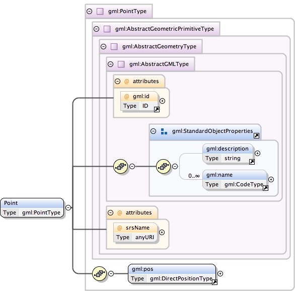
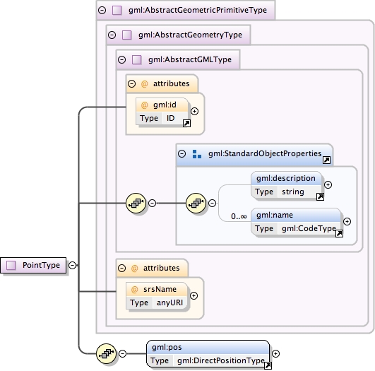
<complexType name="PointType"><annotation><documentation>A Point is defined by a single coordinate tuple.</documentation></annotation><complexContent><extension base="gml:AbstractGeometricPrimitiveType"><sequence><element ref="gml:pos"/></sequence></extension></complexContent></complexType>
Schema location
http://www.tridas.org/1.2/gmlsf.xsd
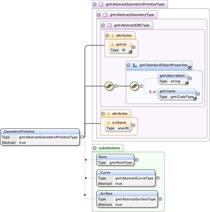
Complex Type gml:AbstractGeometricPrimitiveType
Namespace
http://www.opengis.net/gml
Annotations
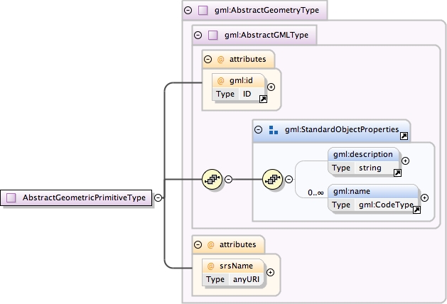
This is the abstract root type of the geometric primitives.
            A geometric primitive is a geometric object that is not
            decomposed further into other primitives in the system.
            All primitives are oriented in the direction implied by
            the sequence of their coordinate tuples.
Database handle for the object.  It is of XML type ID,
            so is constrained to be unique in the XML document within
            which it occurs.  An external identifier for the object
            in the form of a URI may be constructed using standard XML
            and XPointer methods.  This is done by concatenating the
            URI for the document, a fragment separator, and the value
            of the id attribute.
In general this reference points to a CRS instance of
                     gml:CoordinateReferenceSystemType (see
                     coordinateReferenceSystems.xsd). For well known
                     references it is not required that the CRS description
                     exists at the location the URI points to. If no srsName
                     attribute is given, the CRS must be specified as part of
                     the larger context this geometry element is part of, e.g.
                     a geometric element like point, curve, etc. It is expected
                     that this attribute will be specified at the direct
                     position level only in rare cases.
Source
<complexType name="AbstractGeometricPrimitiveType" abstract="true"><annotation><documentation>This is the abstract root type of the geometric primitives. A geometric primitive is a geometric object that is not decomposed further into other primitives in the system. All primitives are oriented in the direction implied by the sequence of their coordinate tuples.</documentation></annotation><complexContent><extension base="gml:AbstractGeometryType"/></complexContent></complexType>
Schema location
http://www.tridas.org/1.2/gmlsf.xsd
Complex Type gml:AbstractGeometryType
Namespace
http://www.opengis.net/gml
Annotations
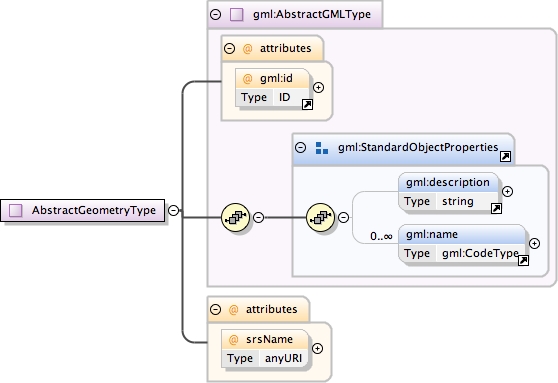
All geometry elements are derived directly or indirectly
            from this abstract supertype. A geometry element may
            have an identifying attribute ("gml:id"), a name (attribute
            "name") and a description (attribute "description"). It may
            be associated with a spatial reference system (attribute
            "srsName"). The following rules shall be adhered: - Every
            geometry type shall derive from this abstract type. - Every
            geometry element (i.e. an element of a geometry type) shall
            be directly or indirectly in the substitution group of _Geometry.
Database handle for the object.  It is of XML type ID,
            so is constrained to be unique in the XML document within
            which it occurs.  An external identifier for the object
            in the form of a URI may be constructed using standard XML
            and XPointer methods.  This is done by concatenating the
            URI for the document, a fragment separator, and the value
            of the id attribute.
In general this reference points to a CRS instance of
                     gml:CoordinateReferenceSystemType (see
                     coordinateReferenceSystems.xsd). For well known
                     references it is not required that the CRS description
                     exists at the location the URI points to. If no srsName
                     attribute is given, the CRS must be specified as part of
                     the larger context this geometry element is part of, e.g.
                     a geometric element like point, curve, etc. It is expected
                     that this attribute will be specified at the direct
                     position level only in rare cases.
Source
<complexType name="AbstractGeometryType" abstract="true"><annotation><documentation>All geometry elements are derived directly or indirectly from this abstract supertype. A geometry element may have an identifying attribute ("gml:id"), a name (attribute "name") and a description (attribute "description"). It may be associated with a spatial reference system (attribute "srsName"). The following rules shall be adhered: - Every geometry type shall derive from this abstract type. - Every geometry element (i.e. an element of a geometry type) shall be directly or indirectly in the substitution group of _Geometry.</documentation></annotation><complexContent><extension base="gml:AbstractGMLType"><attribute name="srsName" type="anyURI" use="optional"><annotation><documentation>In general this reference points to a CRS instance of gml:CoordinateReferenceSystemType (see coordinateReferenceSystems.xsd). For well known references it is not required that the CRS description exists at the location the URI points to. If no srsName attribute is given, the CRS must be specified as part of the larger context this geometry element is part of, e.g. a geometric element like point, curve, etc. It is expected that this attribute will be specified at the direct position level only in rare cases.</documentation></annotation></attribute></extension></complexContent></complexType>
Schema location
http://www.tridas.org/1.2/gmlsf.xsd
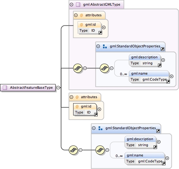
Complex Type gml:AbstractGMLType
Namespace
http://www.opengis.net/gml
Annotations
All complexContent GML elements are directly or indirectly
            derived from this abstract supertype to establish a hierarchy
            of GML types that may be distinguished from other XML types
            by their ancestry.  Elements in this hierarchy must have an
            ID and are thus referenceable.
Database handle for the object.  It is of XML type ID,
            so is constrained to be unique in the XML document within
            which it occurs.  An external identifier for the object
            in the form of a URI may be constructed using standard XML
            and XPointer methods.  This is done by concatenating the
            URI for the document, a fragment separator, and the value
            of the id attribute.
Source
<complexType name="AbstractGMLType" abstract="true"><annotation><documentation>All complexContent GML elements are directly or indirectly derived from this abstract supertype to establish a hierarchy of GML types that may be distinguished from other XML types by their ancestry. Elements in this hierarchy must have an ID and are thus referenceable.</documentation></annotation><sequence><group ref="gml:StandardObjectProperties"/></sequence><attribute ref="gml:id" use="optional"/></complexType>
Schema location
http://www.tridas.org/1.2/gmlsf.xsd
Complex Type gml:CodeType
Namespace
http://www.opengis.net/gml
Annotations
Name or code with an (optional) authority.  Text token.
            If the codeSpace attribute is present, then its value
            should identify a dictionary, thesaurus or authority
            for the term, such as the organisation who assigned
            the value, or the dictionary from which it is taken.
            A text string with an optional codeSpace attribute.
<complexType name="CodeType"><annotation><documentation>Name or code with an (optional) authority. Text token. If the codeSpace attribute is present, then its value should identify a dictionary, thesaurus or authority for the term, such as the organisation who assigned the value, or the dictionary from which it is taken. A text string with an optional codeSpace attribute.</documentation></annotation><simpleContent><extension base="string"><attribute name="codeSpace" type="anyURI" use="optional"/></extension></simpleContent></complexType>
Schema location
http://www.tridas.org/1.2/gmlsf.xsd
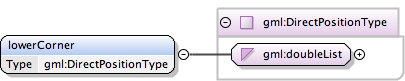
Complex Type gml:DirectPositionType
Namespace
http://www.opengis.net/gml
Annotations
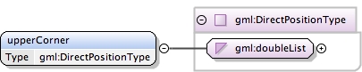
DirectPosition instances hold the coordinates for one position
            in the coordinate reference system (CRS) referenced in a
            larger element. In this case, the CRS shall be assumed to be
            the value referenced in the containing object's CRS.
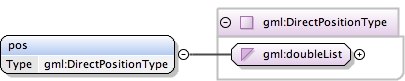
<complexType name="DirectPositionType"><annotation><documentation>DirectPosition instances hold the coordinates for one position in the coordinate reference system (CRS) referenced in a larger element. In this case, the CRS shall be assumed to be the value referenced in the containing object's CRS.</documentation></annotation><simpleContent><extension base="gml:doubleList"/></simpleContent></complexType>
Schema location
http://www.tridas.org/1.2/gmlsf.xsd
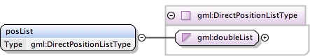
Simple Type gml:doubleList
Namespace
http://www.opengis.net/gml
Annotations
XML List based on XML Schema double type.  An element
            of this type contains a space-separated list of double
            values
<simpleType name="doubleList"><annotation><documentation>XML List based on XML Schema double type. An element of this type contains a space-separated list of double values</documentation></annotation><list itemType="double"/></simpleType>
Schema location
http://www.tridas.org/1.2/gmlsf.xsd
Complex Type gml:PolygonType
Namespace
http://www.opengis.net/gml
Annotations
A Polygon is a special surface that is defined by a single
            surface patch. The boundary of this patch is coplanar and
            the polygon uses planar interpolation in its interior. It
            is backwards compatible with the Polygon of GML 2.
Database handle for the object.  It is of XML type ID,
            so is constrained to be unique in the XML document within
            which it occurs.  An external identifier for the object
            in the form of a URI may be constructed using standard XML
            and XPointer methods.  This is done by concatenating the
            URI for the document, a fragment separator, and the value
            of the id attribute.
In general this reference points to a CRS instance of
                     gml:CoordinateReferenceSystemType (see
                     coordinateReferenceSystems.xsd). For well known
                     references it is not required that the CRS description
                     exists at the location the URI points to. If no srsName
                     attribute is given, the CRS must be specified as part of
                     the larger context this geometry element is part of, e.g.
                     a geometric element like point, curve, etc. It is expected
                     that this attribute will be specified at the direct
                     position level only in rare cases.
Source
<complexType name="PolygonType"><annotation><documentation>A Polygon is a special surface that is defined by a single surface patch. The boundary of this patch is coplanar and the polygon uses planar interpolation in its interior. It is backwards compatible with the Polygon of GML 2.</documentation></annotation><complexContent><extension base="gml:AbstractSurfaceType"><sequence><element ref="gml:exterior" minOccurs="0"/><element ref="gml:interior" minOccurs="0" maxOccurs="unbounded"/></sequence></extension></complexContent></complexType>
Schema location
http://www.tridas.org/1.2/gmlsf.xsd
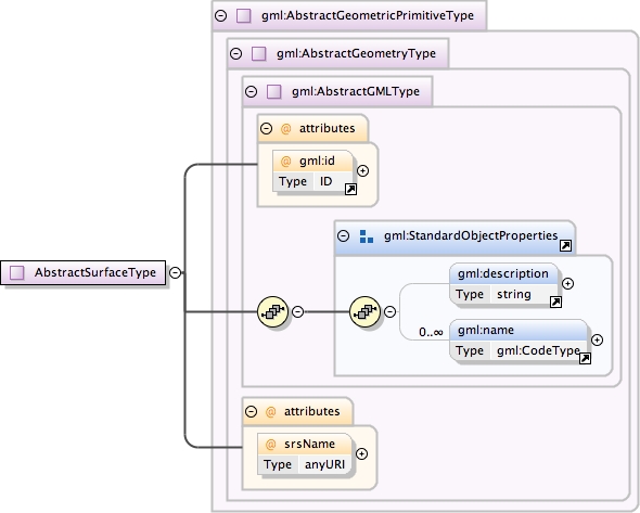
Complex Type gml:AbstractSurfaceType
Namespace
http://www.opengis.net/gml
Annotations
An abstraction of a surface to support the different
            levels of complexity. A surface is always a continuous
            region of a plane.
Database handle for the object.  It is of XML type ID,
            so is constrained to be unique in the XML document within
            which it occurs.  An external identifier for the object
            in the form of a URI may be constructed using standard XML
            and XPointer methods.  This is done by concatenating the
            URI for the document, a fragment separator, and the value
            of the id attribute.
In general this reference points to a CRS instance of
                     gml:CoordinateReferenceSystemType (see
                     coordinateReferenceSystems.xsd). For well known
                     references it is not required that the CRS description
                     exists at the location the URI points to. If no srsName
                     attribute is given, the CRS must be specified as part of
                     the larger context this geometry element is part of, e.g.
                     a geometric element like point, curve, etc. It is expected
                     that this attribute will be specified at the direct
                     position level only in rare cases.
Source
<complexType name="AbstractSurfaceType"><annotation><documentation>An abstraction of a surface to support the different levels of complexity. A surface is always a continuous region of a plane.</documentation></annotation><complexContent><extension base="gml:AbstractGeometricPrimitiveType"/></complexContent></complexType>
Schema location
http://www.tridas.org/1.2/gmlsf.xsd
Complex Type gml:AbstractRingPropertyType
Namespace
http://www.opengis.net/gml
Annotations
Encapsulates a ring to represent the surface boundary property
            of a surface.
<complexType name="AbstractRingPropertyType"><annotation><documentation>Encapsulates a ring to represent the surface boundary property of a surface.</documentation></annotation><sequence><element ref="gml:LinearRing"/></sequence></complexType>
Schema location
http://www.tridas.org/1.2/gmlsf.xsd
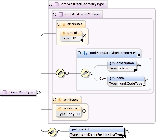
Complex Type gml:LinearRingType
Namespace
http://www.opengis.net/gml
Annotations
A LinearRing is defined by four or more coordinate tuples,
            with linear interpolation between them; the first and last
            coordinates must be coincident.
Database handle for the object.  It is of XML type ID,
            so is constrained to be unique in the XML document within
            which it occurs.  An external identifier for the object
            in the form of a URI may be constructed using standard XML
            and XPointer methods.  This is done by concatenating the
            URI for the document, a fragment separator, and the value
            of the id attribute.
In general this reference points to a CRS instance of
                     gml:CoordinateReferenceSystemType (see
                     coordinateReferenceSystems.xsd). For well known
                     references it is not required that the CRS description
                     exists at the location the URI points to. If no srsName
                     attribute is given, the CRS must be specified as part of
                     the larger context this geometry element is part of, e.g.
                     a geometric element like point, curve, etc. It is expected
                     that this attribute will be specified at the direct
                     position level only in rare cases.
Source
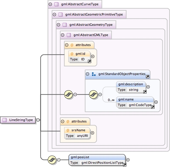
<complexType name="LinearRingType"><annotation><documentation>A LinearRing is defined by four or more coordinate tuples, with linear interpolation between them; the first and last coordinates must be coincident.</documentation></annotation><complexContent><extension base="gml:AbstractGeometryType"><sequence><element ref="gml:posList"><annotation><documentation>The "posList" element provides a compact way to specifiy the coordinates of the control points, if all control points are in the same coordinate reference systems and belong to this ring only. The number of direct positions in the list must be at least four.</documentation></annotation></element></sequence></extension></complexContent></complexType>
Schema location
http://www.tridas.org/1.2/gmlsf.xsd
Complex Type gml:DirectPositionListType
Namespace
http://www.opengis.net/gml
Annotations
DirectPositionList instances hold the coordinates for a
            sequence of direct positions within the same coordinate
            reference system (CRS).
<complexType name="DirectPositionListType"><annotation><documentation>DirectPositionList instances hold the coordinates for a sequence of direct positions within the same coordinate reference system (CRS).</documentation></annotation><simpleContent><extension base="gml:doubleList"/></simpleContent></complexType>
Schema location
http://www.tridas.org/1.2/gmlsf.xsd
Complex Type gml:AbstractGeometricAggregateType
Namespace
http://www.opengis.net/gml
Annotations
This is the abstract root type of the geometric aggregates.
Database handle for the object.  It is of XML type ID,
            so is constrained to be unique in the XML document within
            which it occurs.  An external identifier for the object
            in the form of a URI may be constructed using standard XML
            and XPointer methods.  This is done by concatenating the
            URI for the document, a fragment separator, and the value
            of the id attribute.
In general this reference points to a CRS instance of
                     gml:CoordinateReferenceSystemType (see
                     coordinateReferenceSystems.xsd). For well known
                     references it is not required that the CRS description
                     exists at the location the URI points to. If no srsName
                     attribute is given, the CRS must be specified as part of
                     the larger context this geometry element is part of, e.g.
                     a geometric element like point, curve, etc. It is expected
                     that this attribute will be specified at the direct
                     position level only in rare cases.
Source
<complexType name="AbstractGeometricAggregateType" abstract="true"><annotation><documentation>This is the abstract root type of the geometric aggregates.</documentation></annotation><complexContent><extension base="gml:AbstractGeometryType"/></complexContent></complexType>
Schema location
http://www.tridas.org/1.2/gmlsf.xsd
Complex Type gml:MultiGeometryPropertyType
Namespace
http://www.opengis.net/gml
Annotations
A property that has a geometric aggregate as its value domain
            shall contain an appropriate geometry element encapsulated in
            an element of this type.
<complexType name="MultiGeometryPropertyType"><annotation><documentation>A property that has a geometric aggregate as its value domain shall contain an appropriate geometry element encapsulated in an element of this type.</documentation></annotation><sequence><element ref="gml:_GeometricAggregate"/></sequence></complexType>
Schema location
http://www.tridas.org/1.2/gmlsf.xsd
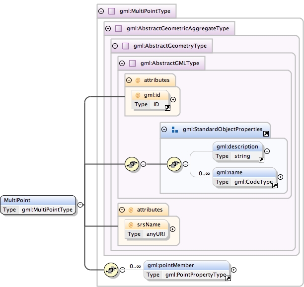
Complex Type gml:MultiPointType
Namespace
http://www.opengis.net/gml
Annotations
A MultiPoint is defined by one or more Points, referenced
            through pointMember elements.
Database handle for the object.  It is of XML type ID,
            so is constrained to be unique in the XML document within
            which it occurs.  An external identifier for the object
            in the form of a URI may be constructed using standard XML
            and XPointer methods.  This is done by concatenating the
            URI for the document, a fragment separator, and the value
            of the id attribute.
In general this reference points to a CRS instance of
                     gml:CoordinateReferenceSystemType (see
                     coordinateReferenceSystems.xsd). For well known
                     references it is not required that the CRS description
                     exists at the location the URI points to. If no srsName
                     attribute is given, the CRS must be specified as part of
                     the larger context this geometry element is part of, e.g.
                     a geometric element like point, curve, etc. It is expected
                     that this attribute will be specified at the direct
                     position level only in rare cases.
Source
<complexType name="MultiPointType"><annotation><documentation>A MultiPoint is defined by one or more Points, referenced through pointMember elements.</documentation></annotation><complexContent><extension base="gml:AbstractGeometricAggregateType"><sequence><element ref="gml:pointMember" minOccurs="0" maxOccurs="unbounded"/></sequence></extension></complexContent></complexType>
Schema location
http://www.tridas.org/1.2/gmlsf.xsd
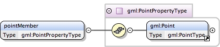
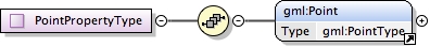
Complex Type gml:PointPropertyType
Namespace
http://www.opengis.net/gml
Annotations
A property that has a point as its value domain shall contain
            an appropriate geometry element encapsulated in an element
            of this type.
<complexType name="PointPropertyType"><annotation><documentation>A property that has a point as its value domain shall contain an appropriate geometry element encapsulated in an element of this type.</documentation></annotation><sequence><element ref="gml:Point"/></sequence></complexType>
Schema location
http://www.tridas.org/1.2/gmlsf.xsd
Complex Type gml:MultiPointPropertyType
Namespace
http://www.opengis.net/gml
Annotations
A property that has a collection of points as its value
            domain shall contain an appropriate geometry element
            encapsulated in an element of this type.
<complexType name="MultiPointPropertyType"><annotation><documentation>A property that has a collection of points as its value domain shall contain an appropriate geometry element encapsulated in an element of this type.</documentation></annotation><sequence><element ref="gml:MultiPoint"/></sequence></complexType>
Schema location
http://www.tridas.org/1.2/gmlsf.xsd
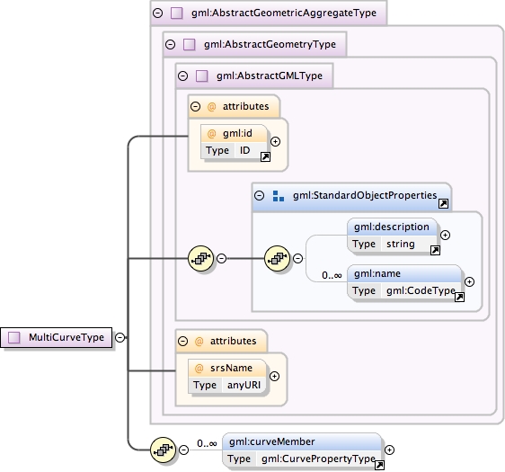
Complex Type gml:MultiCurveType
Namespace
http://www.opengis.net/gml
Annotations
A MultiCurve is defined by one or more Curves, referenced
            through curveMember elements.
Database handle for the object.  It is of XML type ID,
            so is constrained to be unique in the XML document within
            which it occurs.  An external identifier for the object
            in the form of a URI may be constructed using standard XML
            and XPointer methods.  This is done by concatenating the
            URI for the document, a fragment separator, and the value
            of the id attribute.
In general this reference points to a CRS instance of
                     gml:CoordinateReferenceSystemType (see
                     coordinateReferenceSystems.xsd). For well known
                     references it is not required that the CRS description
                     exists at the location the URI points to. If no srsName
                     attribute is given, the CRS must be specified as part of
                     the larger context this geometry element is part of, e.g.
                     a geometric element like point, curve, etc. It is expected
                     that this attribute will be specified at the direct
                     position level only in rare cases.
Source
<complexType name="MultiCurveType"><annotation><documentation>A MultiCurve is defined by one or more Curves, referenced through curveMember elements.</documentation></annotation><complexContent><extension base="gml:AbstractGeometricAggregateType"><sequence><element ref="gml:curveMember" minOccurs="0" maxOccurs="unbounded"/></sequence></extension></complexContent></complexType>
Schema location
http://www.tridas.org/1.2/gmlsf.xsd
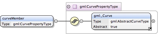
Complex Type gml:CurvePropertyType
Namespace
http://www.opengis.net/gml
Annotations
A property that has a curve as its value domain shall contain
            an appropriate geometry element encapsulated in an element
            of this type.
<complexType name="CurvePropertyType"><annotation><documentation>A property that has a curve as its value domain shall contain an appropriate geometry element encapsulated in an element of this type.</documentation></annotation><sequence><element ref="gml:_Curve"/></sequence></complexType>
Schema location
http://www.tridas.org/1.2/gmlsf.xsd
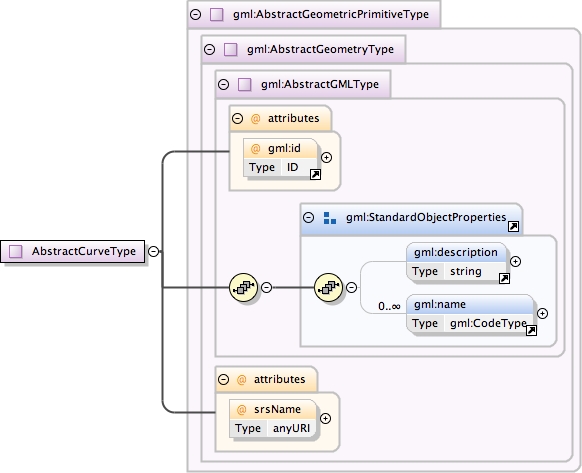
Complex Type gml:AbstractCurveType
Namespace
http://www.opengis.net/gml
Annotations
An abstraction of a curve to support the different levels
            of complexity. The curve can always be viewed as a geometric
            primitive, i.e. is continuous.
Database handle for the object.  It is of XML type ID,
            so is constrained to be unique in the XML document within
            which it occurs.  An external identifier for the object
            in the form of a URI may be constructed using standard XML
            and XPointer methods.  This is done by concatenating the
            URI for the document, a fragment separator, and the value
            of the id attribute.
In general this reference points to a CRS instance of
                     gml:CoordinateReferenceSystemType (see
                     coordinateReferenceSystems.xsd). For well known
                     references it is not required that the CRS description
                     exists at the location the URI points to. If no srsName
                     attribute is given, the CRS must be specified as part of
                     the larger context this geometry element is part of, e.g.
                     a geometric element like point, curve, etc. It is expected
                     that this attribute will be specified at the direct
                     position level only in rare cases.
Source
<complexType name="AbstractCurveType" abstract="true"><annotation><documentation>An abstraction of a curve to support the different levels of complexity. The curve can always be viewed as a geometric primitive, i.e. is continuous.</documentation></annotation><complexContent><extension base="gml:AbstractGeometricPrimitiveType"/></complexContent></complexType>
Schema location
http://www.tridas.org/1.2/gmlsf.xsd
Complex Type gml:MultiCurvePropertyType
Namespace
http://www.opengis.net/gml
Annotations
A property that has a collection of curves as its value domain
            shall contain an appropriate geometry element encapsulated in
            an element of this type.
<complexType name="MultiCurvePropertyType"><annotation><documentation>A property that has a collection of curves as its value domain shall contain an appropriate geometry element encapsulated in an element of this type.</documentation></annotation><sequence><element ref="gml:MultiCurve"/></sequence></complexType>
Schema location
http://www.tridas.org/1.2/gmlsf.xsd
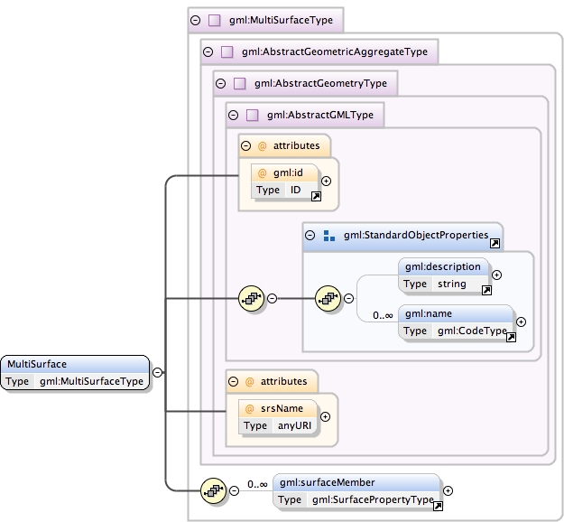
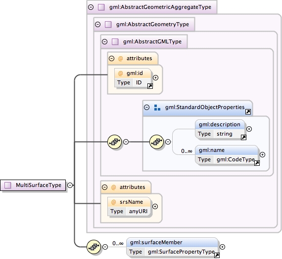
Complex Type gml:MultiSurfaceType
Namespace
http://www.opengis.net/gml
Annotations
A MultiSurface is defined by one or more Surfaces,
            referenced through surfaceMember elements.
Database handle for the object.  It is of XML type ID,
            so is constrained to be unique in the XML document within
            which it occurs.  An external identifier for the object
            in the form of a URI may be constructed using standard XML
            and XPointer methods.  This is done by concatenating the
            URI for the document, a fragment separator, and the value
            of the id attribute.
In general this reference points to a CRS instance of
                     gml:CoordinateReferenceSystemType (see
                     coordinateReferenceSystems.xsd). For well known
                     references it is not required that the CRS description
                     exists at the location the URI points to. If no srsName
                     attribute is given, the CRS must be specified as part of
                     the larger context this geometry element is part of, e.g.
                     a geometric element like point, curve, etc. It is expected
                     that this attribute will be specified at the direct
                     position level only in rare cases.
Source
<complexType name="MultiSurfaceType"><annotation><documentation>A MultiSurface is defined by one or more Surfaces, referenced through surfaceMember elements.</documentation></annotation><complexContent><extension base="gml:AbstractGeometricAggregateType"><sequence><element ref="gml:surfaceMember" minOccurs="0" maxOccurs="unbounded"/></sequence></extension></complexContent></complexType>
Schema location
http://www.tridas.org/1.2/gmlsf.xsd
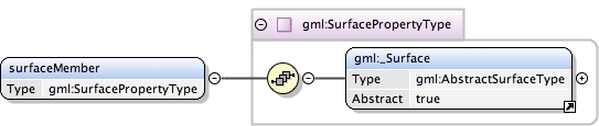
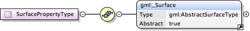
Complex Type gml:SurfacePropertyType
Namespace
http://www.opengis.net/gml
Annotations
A property that has a surface as its value domain shall contain
            an appropriate geometry element encapsulated in an element
            of this type.
<complexType name="SurfacePropertyType"><annotation><documentation>A property that has a surface as its value domain shall contain an appropriate geometry element encapsulated in an element of this type.</documentation></annotation><sequence><element ref="gml:_Surface"/></sequence></complexType>
Schema location
http://www.tridas.org/1.2/gmlsf.xsd
Complex Type gml:MultiSurfacePropertyType
Namespace
http://www.opengis.net/gml
Annotations
A property that has a collection of surfaces as its value
            domain shall contain an appropriate geometry element
            encapsulated in an element of this type.
<complexType name="MultiSurfacePropertyType"><annotation><documentation>A property that has a collection of surfaces as its value domain shall contain an appropriate geometry element encapsulated in an element of this type.</documentation></annotation><sequence><element ref="gml:MultiSurface"/></sequence></complexType>
Schema location
http://www.tridas.org/1.2/gmlsf.xsd
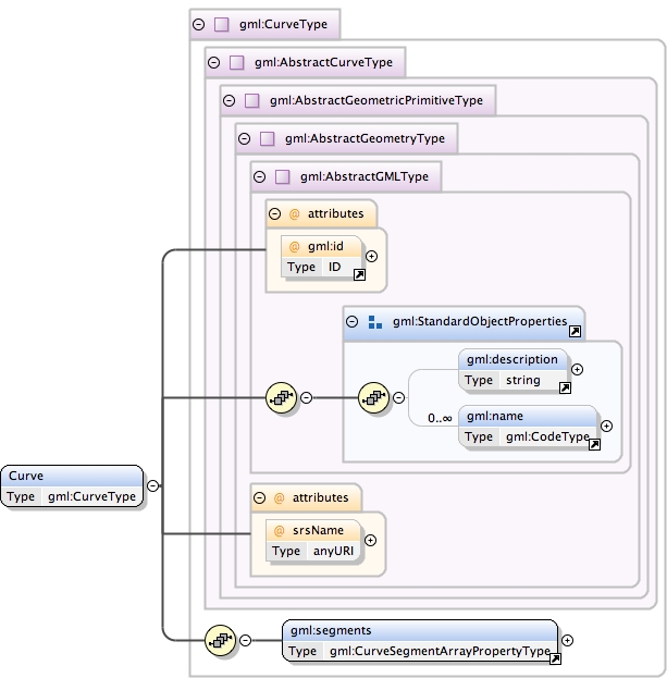
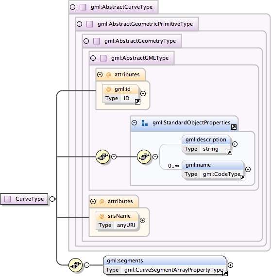
Complex Type gml:CurveType
Namespace
http://www.opengis.net/gml
Annotations
Curve is a 1-dimensional primitive. Curves are continuous,
            connected, and have a measurable length in terms of the
            coordinate system.
            A curve is composed of one or more curve segments.
            The curve segments are connected to one another, with the
            end point of each segment except the last being the start
            point of the next segment in the segment list.
            The orientation of the curve is positive.
Database handle for the object.  It is of XML type ID,
            so is constrained to be unique in the XML document within
            which it occurs.  An external identifier for the object
            in the form of a URI may be constructed using standard XML
            and XPointer methods.  This is done by concatenating the
            URI for the document, a fragment separator, and the value
            of the id attribute.
In general this reference points to a CRS instance of
                     gml:CoordinateReferenceSystemType (see
                     coordinateReferenceSystems.xsd). For well known
                     references it is not required that the CRS description
                     exists at the location the URI points to. If no srsName
                     attribute is given, the CRS must be specified as part of
                     the larger context this geometry element is part of, e.g.
                     a geometric element like point, curve, etc. It is expected
                     that this attribute will be specified at the direct
                     position level only in rare cases.
Source
<complexType name="CurveType"><annotation><documentation>Curve is a 1-dimensional primitive. Curves are continuous, connected, and have a measurable length in terms of the coordinate system. A curve is composed of one or more curve segments. The curve segments are connected to one another, with the end point of each segment except the last being the start point of the next segment in the segment list. The orientation of the curve is positive.</documentation></annotation><complexContent><extension base="gml:AbstractCurveType"><sequence><element ref="gml:segments"><annotation><documentation>This element encapsulates the segments of the curve.</documentation></annotation></element></sequence></extension></complexContent></complexType>
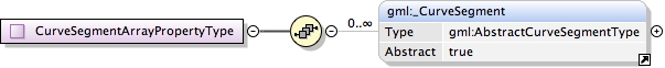
<complexType name="CurveSegmentArrayPropertyType"><annotation><documentation>A container for an array of curve segments.</documentation></annotation><sequence><element ref="gml:_CurveSegment" minOccurs="0" maxOccurs="unbounded"/></sequence></complexType>
Schema location
http://www.tridas.org/1.2/gmlsf.xsd
Complex Type gml:AbstractCurveSegmentType
Namespace
http://www.opengis.net/gml
Annotations
Curve segment defines a homogeneous segment of a curve.
<complexType name="AbstractCurveSegmentType" abstract="true"><annotation><documentation>Curve segment defines a homogeneous segment of a curve.</documentation></annotation><sequence/></complexType>
Schema location
http://www.tridas.org/1.2/gmlsf.xsd
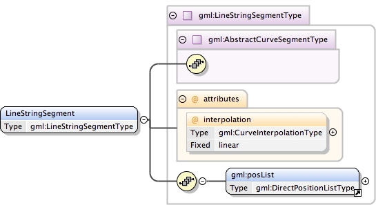
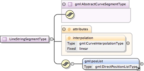
Complex Type gml:LineStringSegmentType
Namespace
http://www.opengis.net/gml
Annotations
A LineStringSegment is a curve segment that is defined by
            two or more coordinate tuples, with linear interpolation
            between them.
            Note: LineStringSegment implements GM_LineString of ISO 19107.
The attribute "interpolation" specifies
                     the curve interpolation mechanism used
                     for this segment. This mechanism uses
                     the control points and control parameters
                     to determine the position of this curve
                     segment. For a LineStringSegment the
                     interpolation is fixed as "linear".
Source
<complexType name="LineStringSegmentType"><annotation><documentation>A LineStringSegment is a curve segment that is defined by two or more coordinate tuples, with linear interpolation between them. Note: LineStringSegment implements GM_LineString of ISO 19107.</documentation></annotation><complexContent><extension base="gml:AbstractCurveSegmentType"><sequence><element ref="gml:posList"/></sequence><attribute name="interpolation" type="gml:CurveInterpolationType" fixed="linear"><annotation><documentation>The attribute "interpolation" specifies the curve interpolation mechanism used for this segment. This mechanism uses the control points and control parameters to determine the position of this curve segment. For a LineStringSegment the interpolation is fixed as "linear".</documentation></annotation></attribute></extension></complexContent></complexType>
Schema location
http://www.tridas.org/1.2/gmlsf.xsd
Simple Type gml:CurveInterpolationType
Namespace
http://www.opengis.net/gml
Annotations
CurveInterpolationType is a list of codes that may be
            used to identify the interpolation mechanisms specified
            by an schema.
<simpleType name="CurveInterpolationType"><annotation><documentation>CurveInterpolationType is a list of codes that may be used to identify the interpolation mechanisms specified by an schema.</documentation></annotation><restriction base="string"><enumeration value="linear"/></restriction></simpleType>
Schema location
http://www.tridas.org/1.2/gmlsf.xsd
Complex Type gml:AbstractSurfacePatchType
Namespace
http://www.opengis.net/gml
Annotations
A surface patch defines a homogenuous portion of a surface.
<complexType name="AbstractSurfacePatchType" abstract="true"><annotation><documentation>A surface patch defines a homogenuous portion of a surface.</documentation></annotation><sequence/></complexType>
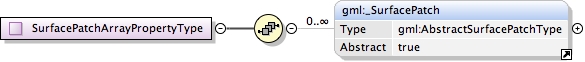
<complexType name="SurfacePatchArrayPropertyType"><annotation><documentation>A container for an array of surface patches.</documentation></annotation><sequence><element ref="gml:_SurfacePatch" minOccurs="0" maxOccurs="unbounded"/></sequence></complexType>
Schema location
http://www.tridas.org/1.2/gmlsf.xsd
Complex Type gml:PolygonPatchType
Namespace
http://www.opengis.net/gml
Annotations
A PolygonPatch is a surface patch that is defined by
            a set of boundary curves and an underlying surface to
            which these curves adhere. The curves are coplanar and
            the polygon uses planar interpolation in its interior.
            Implements GM_Polygon of ISO 19107.
The attribute "interpolation" specifies the
                     interpolation mechanism used for this surface
                     patch. Currently only planar surface patches
                     are defined in GML 3, the attribute is fixed
                     to "planar", i.e. the interpolation method
                     shall return points on a single plane. The
                     boundary of the patch shall be contained within
                     that plane.
Source
<complexType name="PolygonPatchType"><annotation><documentation>A PolygonPatch is a surface patch that is defined by a set of boundary curves and an underlying surface to which these curves adhere. The curves are coplanar and the polygon uses planar interpolation in its interior. Implements GM_Polygon of ISO 19107.</documentation></annotation><complexContent><extension base="gml:AbstractSurfacePatchType"><sequence><element ref="gml:exterior" minOccurs="0"/><element ref="gml:interior" minOccurs="0" maxOccurs="unbounded"/></sequence><attribute name="interpolation" type="gml:SurfaceInterpolationType" fixed="planar"><annotation><documentation>The attribute "interpolation" specifies the interpolation mechanism used for this surface patch. Currently only planar surface patches are defined in GML 3, the attribute is fixed to "planar", i.e. the interpolation method shall return points on a single plane. The boundary of the patch shall be contained within that plane.</documentation></annotation></attribute></extension></complexContent></complexType>
Schema location
http://www.tridas.org/1.2/gmlsf.xsd
Simple Type gml:SurfaceInterpolationType
Namespace
http://www.opengis.net/gml
Annotations
SurfaceInterpolationType is a list of codes that may be
            used to identify the interpolation mechanisms specified
            by an application schema.
<simpleType name="SurfaceInterpolationType"><annotation><documentation>SurfaceInterpolationType is a list of codes that may be used to identify the interpolation mechanisms specified by an application schema.</documentation></annotation><restriction base="string"><enumeration value="planar"/></restriction></simpleType>
Schema location
http://www.tridas.org/1.2/gmlsf.xsd
Complex Type gml:SurfaceType
Namespace
http://www.opengis.net/gml
Annotations
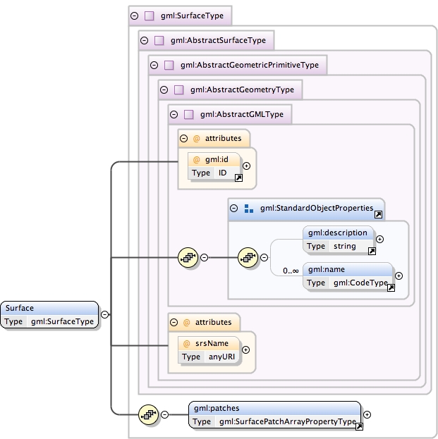
A Surface is a 2-dimensional primitive and is composed
            of one or more surface patches. The surface patches are
            connected to one another.
            The orientation of the surface is positive ("up"). The
            orientation of a surface chooses an "up" direction
            through the choice of the upward normal, which, if the
            surface is not a cycle, is the side of the surface from
            which the exterior boundary appears counterclockwise.
            Reversal of the surface orientation reverses the curve
            orientation of each boundary component, and interchanges
            the conceptual "up" and "down" direction of the surface.
            If the surface is the boundary of a solid, the "up"
            direction is usually outward. For closed surfaces, which
            have no boundary, the up direction is that of the surface
            patches, which must be consistent with one another. Its
            included surface patches describe the interior structure
            of the Surface.
Database handle for the object.  It is of XML type ID,
            so is constrained to be unique in the XML document within
            which it occurs.  An external identifier for the object
            in the form of a URI may be constructed using standard XML
            and XPointer methods.  This is done by concatenating the
            URI for the document, a fragment separator, and the value
            of the id attribute.
In general this reference points to a CRS instance of
                     gml:CoordinateReferenceSystemType (see
                     coordinateReferenceSystems.xsd). For well known
                     references it is not required that the CRS description
                     exists at the location the URI points to. If no srsName
                     attribute is given, the CRS must be specified as part of
                     the larger context this geometry element is part of, e.g.
                     a geometric element like point, curve, etc. It is expected
                     that this attribute will be specified at the direct
                     position level only in rare cases.
Source
<complexType name="SurfaceType"><annotation><documentation>A Surface is a 2-dimensional primitive and is composed of one or more surface patches. The surface patches are connected to one another. The orientation of the surface is positive ("up"). The orientation of a surface chooses an "up" direction through the choice of the upward normal, which, if the surface is not a cycle, is the side of the surface from which the exterior boundary appears counterclockwise. Reversal of the surface orientation reverses the curve orientation of each boundary component, and interchanges the conceptual "up" and "down" direction of the surface. If the surface is the boundary of a solid, the "up" direction is usually outward. For closed surfaces, which have no boundary, the up direction is that of the surface patches, which must be consistent with one another. Its included surface patches describe the interior structure of the Surface.</documentation></annotation><complexContent><extension base="gml:AbstractSurfaceType"><sequence><element ref="gml:patches"><annotation><documentation>This element encapsulates the patches of the surface.</documentation></annotation></element></sequence></extension></complexContent></complexType>
Schema location
http://www.tridas.org/1.2/gmlsf.xsd
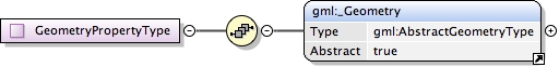
Complex Type gml:GeometryPropertyType
Namespace
http://www.opengis.net/gml
Annotations
A geometric property shall contain any geometry element
            encapsulated in an element of this type.
<complexType name="GeometryPropertyType"><annotation><documentation>A geometric property shall contain any geometry element encapsulated in an element of this type.</documentation></annotation><sequence><element ref="gml:_Geometry"/></sequence></complexType>
Schema location
http://www.tridas.org/1.2/gmlsf.xsd
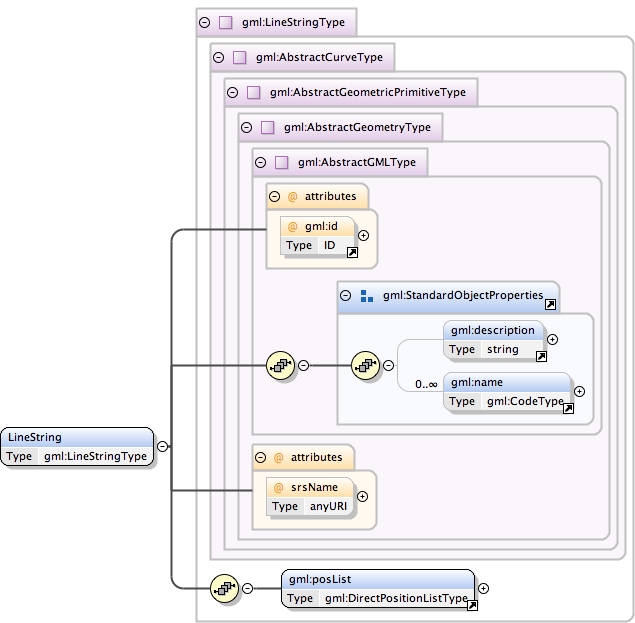
Complex Type gml:LineStringType
Namespace
http://www.opengis.net/gml
Annotations
A LineString is a special curve that consists of a
            single segment with linear interpolation. It is defined
            by two or more coordinate tuples, with linear interpolation
            between them. It is backwards compatible with the LineString
            of GML 2.
Database handle for the object.  It is of XML type ID,
            so is constrained to be unique in the XML document within
            which it occurs.  An external identifier for the object
            in the form of a URI may be constructed using standard XML
            and XPointer methods.  This is done by concatenating the
            URI for the document, a fragment separator, and the value
            of the id attribute.
In general this reference points to a CRS instance of
                     gml:CoordinateReferenceSystemType (see
                     coordinateReferenceSystems.xsd). For well known
                     references it is not required that the CRS description
                     exists at the location the URI points to. If no srsName
                     attribute is given, the CRS must be specified as part of
                     the larger context this geometry element is part of, e.g.
                     a geometric element like point, curve, etc. It is expected
                     that this attribute will be specified at the direct
                     position level only in rare cases.
Source
<complexType name="LineStringType"><annotation><documentation>A LineString is a special curve that consists of a single segment with linear interpolation. It is defined by two or more coordinate tuples, with linear interpolation between them. It is backwards compatible with the LineString of GML 2.</documentation></annotation><complexContent><extension base="gml:AbstractCurveType"><sequence><element ref="gml:posList"/></sequence></extension></complexContent></complexType>
Schema location
http://www.tridas.org/1.2/gmlsf.xsd
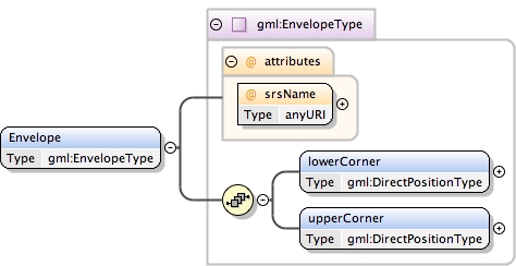
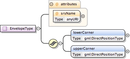
Complex Type gml:EnvelopeType
Namespace
http://www.opengis.net/gml
Annotations
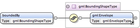
Envelope defines an extent using a pair of positions
            defining opposite corners in arbitrary dimensions. The
            first direct position is the "lower corner" (a coordinate
            position consisting of all the minimal ordinates for each
            dimension for all points within the envelope), the second
            one the "upper corner" (a coordinate position consisting
            of all the maximal ordinates for each dimension for all
            points within the envelope).
In general this reference points to a CRS instance of
               gml:CoordinateReferenceSystemType (see
               coordinateReferenceSystems.xsd). For well known
               references it is not required that the CRS description
               exists at the location the URI points to.
Source
<complexType name="EnvelopeType"><annotation><documentation>Envelope defines an extent using a pair of positions defining opposite corners in arbitrary dimensions. The first direct position is the "lower corner" (a coordinate position consisting of all the minimal ordinates for each dimension for all points within the envelope), the second one the "upper corner" (a coordinate position consisting of all the maximal ordinates for each dimension for all points within the envelope).</documentation></annotation><sequence><element name="lowerCorner" type="gml:DirectPositionType"/><element name="upperCorner" type="gml:DirectPositionType"/></sequence><attribute name="srsName" type="anyURI" use="required"><annotation><documentation>In general this reference points to a CRS instance of gml:CoordinateReferenceSystemType (see coordinateReferenceSystems.xsd). For well known references it is not required that the CRS description exists at the location the URI points to.</documentation></annotation></attribute></complexType>
Schema location
http://www.tridas.org/1.2/gmlsf.xsd
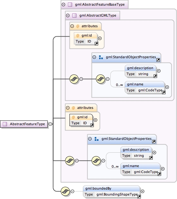
Complex Type gml:AbstractFeatureType
Namespace
http://www.opengis.net/gml
Annotations
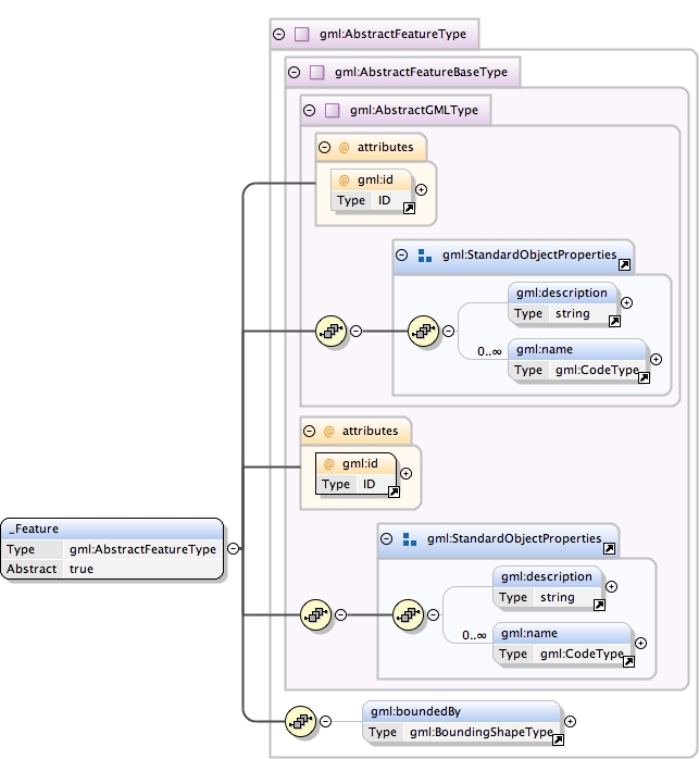
An abstract feature provides a set of common properties,
            including id, name and description inherited from
            AbstractGMLType, plus boundedBy.  A concrete feature type
            must derive from this type and specify additional properties
            in an application schema.
Database handle for the object.  It is of XML type ID,
            so is constrained to be unique in the XML document within
            which it occurs.  An external identifier for the object
            in the form of a URI may be constructed using standard XML
            and XPointer methods.  This is done by concatenating the
            URI for the document, a fragment separator, and the value
            of the id attribute.
Source
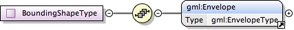
<complexType name="AbstractFeatureType" abstract="true"><annotation><documentation>An abstract feature provides a set of common properties, including id, name and description inherited from AbstractGMLType, plus boundedBy. A concrete feature type must derive from this type and specify additional properties in an application schema.</documentation></annotation><complexContent><extension base="gml:AbstractFeatureBaseType"><sequence><element ref="gml:boundedBy" minOccurs="0"/><!-- additional properties must be specified in an
application schema --></sequence></extension></complexContent></complexType>
Schema location
http://www.tridas.org/1.2/gmlsf.xsd
Complex Type gml:AbstractFeatureBaseType
Namespace
http://www.opengis.net/gml
Annotations
A abstract feature base type, that shall include an
            identifying attribute ('id').
Database handle for the object.  It is of XML type ID,
            so is constrained to be unique in the XML document within
            which it occurs.  An external identifier for the object
            in the form of a URI may be constructed using standard XML
            and XPointer methods.  This is done by concatenating the
            URI for the document, a fragment separator, and the value
            of the id attribute.
Source
<complexType name="AbstractFeatureBaseType"><annotation><documentation>A abstract feature base type, that shall include an identifying attribute ('id').</documentation></annotation><complexContent><restriction base="gml:AbstractGMLType"><sequence><group ref="gml:StandardObjectProperties"/></sequence><attribute ref="gml:id" use="required"/></restriction></complexContent></complexType>
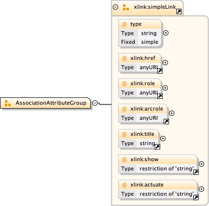
A pattern or base for derived types used to specify complex types corresponding to a UML aggregation association. An instance of this type serves as a pointer to a remote Object.
The 'actuate' attribute is used to communicate the desired timing of traversal from the starting resource to the ending resource; it's value should be treated as follows: onLoad - traverse to the ending resource immediately on loading the starting resource onRequest - traverse from the starting resource to the ending resource only on a post-loading event triggered for this purpose other - behavior is unconstrained; examine other markup in link for hints none - behavior is unconstrained
The 'show' attribute is used to communicate the desired presentation of the ending resource on traversal from the starting resource; it's value should be treated as follows: new - load ending resource in a new window, frame, pane, or other presentation context replace - load the resource in the same window, frame, pane, or other presentation context embed - load ending resource in place of the presentation of the starting resource other - behavior is unconstrained; examine other markup in the link for hints none - behavior is unconstrained
<complexType name="ReferenceType"><annotation><documentation>A pattern or base for derived types used to specify complex types corresponding to a UML aggregation association. An instance of this type serves as a pointer to a remote Object.</documentation></annotation><attributeGroup ref="gml:AssociationAttributeGroup"/></complexType>
Schema location
http://www.tridas.org/1.2/gmlsf.xsd
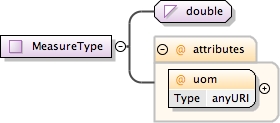
Complex Type gml:MeasureType
Namespace
http://www.opengis.net/gml
Annotations
Number with a scale. The value of uom (Units Of Measure) attribute is a reference to a Reference System for the amount, either a ratio or position scale.
<complexType name="MeasureType"><annotation><documentation>Number with a scale. The value of uom (Units Of Measure) attribute is a reference to a Reference System for the amount, either a ratio or position scale.</documentation></annotation><simpleContent><extension base="double"><attribute name="uom" type="anyURI" use="required"/></extension></simpleContent></complexType>
Schema location
http://www.tridas.org/1.2/gmlsf.xsd
Simple Type gml:NCNameList
Namespace
http://www.opengis.net/gml
Annotations
A set of values, representing a list of token with the lexical value space of NCName. The tokens are seperated by whitespace.
Diagram
Type
list of NCName
Source
<simpleType name="NCNameList"><annotation><documentation>A set of values, representing a list of token with the lexical value space of NCName. The tokens are seperated by whitespace.</documentation></annotation><list itemType="NCName"/></simpleType>
Schema location
http://www.tridas.org/1.2/gmlsf.xsd
Attribute @gml:id
Namespace
http://www.opengis.net/gml
Annotations
Database handle for the object. It is of XML type ID, so is constrained to be unique in the XML document within which it occurs. An external identifier for the object in the form of a URI may be constructed using standard XML and XPointer methods. This is done by concatenating the URI for the document, a fragment separator, and the value of the id attribute.
<attribute name="id" type="ID"><annotation><documentation>Database handle for the object. It is of XML type ID, so is constrained to be unique in the XML document within which it occurs. An external identifier for the object in the form of a URI may be constructed using standard XML and XPointer methods. This is done by concatenating the URI for the document, a fragment separator, and the value of the id attribute.</documentation></annotation></attribute>
<group name="StandardObjectProperties"><annotation><documentation>This content model group makes it easier to construct types that derive from AbstractGMLType and its descendents "by restriction". A reference to the group saves having to enumerate the standard object properties.</documentation></annotation><sequence><element ref="gml:description" minOccurs="0"/><element ref="gml:name" minOccurs="0" maxOccurs="unbounded"><annotation><documentation>Multiple names may be provided. These will often be distinguished by being assigned by different authorities, as indicated by the value of the codeSpace attribute. In an instance document there will usually only be one name per authority.</documentation></annotation></element></sequence></group>
The 'actuate' attribute is used to communicate the desired timing of traversal from the starting resource to the ending resource; it's value should be treated as follows: onLoad - traverse to the ending resource immediately on loading the starting resource onRequest - traverse from the starting resource to the ending resource only on a post-loading event triggered for this purpose other - behavior is unconstrained; examine other markup in link for hints none - behavior is unconstrained
The 'show' attribute is used to communicate the desired presentation of the ending resource on traversal from the starting resource; it's value should be treated as follows: new - load ending resource in a new window, frame, pane, or other presentation context replace - load the resource in the same window, frame, pane, or other presentation context embed - load ending resource in place of the presentation of the starting resource other - behavior is unconstrained; examine other markup in the link for hints none - behavior is unconstrained
<attributeGroup name="AssociationAttributeGroup"><annotation><documentation>Attribute group used to enable property elements to refer to their value remotely. It contains the simple link components from xlinks.xsd, with all members optional. These attributes can be attached to any element, thus allowing it to act as a pointer.</documentation></annotation><attributeGroup ref="xlink:simpleLink"/></attributeGroup>